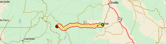
Tour Day 24: Clayton, ID to Stanley, ID

September 10th, 2007

49.96 mi / 4:11:13 time / 11.9 mph avg. / 20.5 mph max. / 1909 ft. climbing
Staying at Stanley Lake Inlet National Forest Campground

Milky WayThere was some great star-gazing last night, where the bright band of the Milky Way inevitably draws your eyes upward, even on a simple walk to the toilet. In the morning, I stayed in the tent a little longer than usual, both because I knew I had a short day coming, and because I wanted the sun to rise over the mountains to warm things up a little bit.

When I did roll out, I happened to check my front tire for some reason, and found it completely flat. I have no idea why, since the tube seemed fine when I took it out. But since it was the front tire and I hadn’t packed up the bike yet, it was a simple tube change. Much better when these things happen in camp than when on the road!

Sawtooth National Recreation AreaThe morning presented itself with high-pressure deep blue skies and very little wind, a perfect day for cycling in a great environment. I continued winding up the Salmon River Valley. As I gained elevation, the evergreen trees began coming down the mountainsides and replacing the sagebrush. At some point, the National Forest guys came along and said to the Bureau of Land Management guys “see, there are trees now, we can take it from here.”

Since it was a short day, I stopped at every little roadside marker and display, two of which were very cool. The first was a salmon spawning ground, and quite serendipitously, the salmon were actually spawning there (in the Salmon River, no less!) Salmon Spawning, Salmon River A 900-mile trip upriver, to breed and die. While I’m also traveling upriver, I’ll try to avoid the following their example too far. I guess if I had a canoe, that means I could also put in right there and float down the Salmon to the Snake to the Columbia and all the way to Portland. The other stop was at a hot spring coming out of the mountainside and flowed into the river. This was nice because, unlike all the fragile areas at Yellowstone, I could actually walk over to the spring, put my hand in it, and say “damn, they don’t call it a hot spring for nothing!”

I ate no Little Debbie products today, because the place I stopped at was a Hostess shop. Most places are either Hostess or Little Debbie; only very rarely will a place sell both, and in those cases, the racks are usually well separated. Hostess is good, but it’s not better than Little Debbie, and it’s way more expensive. Anyway, I got an Apple Pie, and then a Big Texas Cinnamon Roll from an independent bakery. The Roll actually had an emblem on the package declaring that it was 2007 Snack Cake of the year or something like that, so I had to get it. Turns out it’s from the Clover Hill Bakery, which is located where? That’s right, Chicago, Illinois.

McGown Peak, Sawtooth MountainsStanley is another town that sits at a flat river confluence, surrounded by high mountains. These are the Sawtooths, and they are aptly named, for they’re the most jagged and pointy mountains I’ve seen so far. I was expecting Stanley to be more resort-like, since it’s “The Gateway to the Sawtooth Wilderness”, but I guess maybe wilderness travelers are looking for wilderness, not resorts. The town center is actually on gravel roads. I got my third identical roast-beef deli sandwich in as many days, and then spent a long time in the library (which doubles as the librarian’s house, I think) figuring out the last week of the trip.

Then it was nine more miles up to the campground at Stanley Lake, where I got a lakeside campsite with an amazing view of the mountains. Unfortunately the air is a bit hazy (smoky?) so it doesn’t make for the best pictures.

Day 24

Tour Day 23: Mackay, ID to Clayton, ID

September 9th, 2007

66.02 mi / 5:42:51 time / 11.5 mph avg. / 25.5 mph max. / 2292 ft. climbing
Staying at East Fork BLM Campground

Lost River RangeI was wrong about the Wind Gods yesterday. They weren’t repaying their debts, they were loaning me free wind, and today, they wanted to be paid back. The first section of the day was admittedly a 1000 foot climb over a pass, but I had 25 miles to do it in, so that doesn’t sound too bad. But it took me three hours of riding, at an average speed of 8.5 mph. Oh boy was it brutal. Even when I was headed straight toward a mountain to the north of me, the wind was still blowing fiercely out of the north. Where was it coming from? Straight out of the mountain?

Borah Peak, Highest Point In IdahoOn the way I passed Mt. Borah, the highest point in Idaho, although I’m not exactly sure which one it was (there are a lot of 12,000+ ft. peaks in the area). I’m guessing it was the one I could see some trickles of ice on. It’s interesting that I’ve come within a few miles of the highest points in the states of Illinois, Iowa, South Dakota, and Idaho. I don’t really count Montana, and I’ll be going pretty close to Mt. Hood, which must be the highest point in Oregon. That just leaves Wyoming, which must have the Tetons for the high point. Maybe I should have went there instead of spending an extra day in Yellowstone!

Once I crested that stupid pass, then it was a long downhill towards Challis. The wind must have lightened a little, because I didn’t have to push that hard on the downhill to maintain a decent speed. At one point I went through the surprising Grand View Canyon for a mile or two, which is a really narrow, straight-walled rocky canyon. I guess a river must have run through it at one point, but now there’s just a road. And a lot of graffiti on the rocks, which is weird, because it’s kind of in the middle of nowhere.

Near Challis, IdahoOnce through the canyon, I could see Challis from miles and miles away. It sits in a big flat valley, completely surrounded by a ring of mountains. Luckily the gas station at the intersection of US 93 and ID 75 (where I would be turning from northwest to southwest) had deli sandwiches (another roast beef that was almost identical to the one in Arco!) and enough groceries so I didn’t have to do the couple extra miles out of my way north to town.

Salmon River ValleyThen I turned southwest and headed up the Salmon River. That meant climbing again, but now I had the wind with me, so it was pretty easy. The entrance to the valley was the narrowest, steepest-walled river valley that I’ve been in (excepting the Grand Canyon of the Yellowstone, which doesn’t actually have a road running through the bottom). There was a sign telling me to watch out for bighorn sheep on the road, but unfortunately I didn’t see any. Eventually the valley widened, and, as usual, the farmers and ranchers took advantage of every bit of flat ground to create unnatural plots of green in the near-desert conditions.

Hmm, have you noticed that I picked up Backpacker Magazine’s Global Warming Issue yesterday? It basically goes on and on about how all our National Parks are doomed. All the glaciers are going to disappear, and the forests are going to get all crappy. I saw a lot of evidence of mountain pine beetle leaving huge stands of pine trees gray and dead in both the Bighorns and Yellowstone…I don’t know if those particular instances were global-warming fueled (the beetle is infesting much broader areas as temperatures increase), but they sure didn’t look pretty. So if all the stuff I’m writing about and taking pictures of sounds interesting to you, go see it now, before it’s gone!

East Fork BLM CampgroundIt seems like just about everyone I’ve talked to in the last few days, including the campground host tonight, has said “Portland? That’s a long way to go!” when I tell them that I’m riding from Chicago to Portland. They seem to completely miss the fact that Chicago to Idaho is over twice as far. I can only guess that it’s because Portland is close enough so they have a fair idea how far away it is, whereas Chicago is some nebulous area in who-the-hell-knows-where.

Day 23

Tour Day 22: Terreton, ID to Mackay, ID

September 8th, 2007

99.66 mi / 6:32:06 time / 15.2 mph avg. / 25.0 mph max. / 2149 ft. climbing
Staying at Joseph T. Fallini BLM Campground

Idaho Mountain RangesI don’t think a guy could have an easier time covering (nearly) 100 miles. The Wind Gods repaid their debt from yesterday, and I had tailwinds the whole way, whether I was traveling west, south, or northwest. I spent a lot of time cruising at around 19mph, sometimes even on the uphills (and there were no downhills today either, it was all flat or rising).

The night stayed unusually warm, to the point where I stripped down to my underwear inside the sleeping bag. I had pitched the tent on a concrete slab, so maybe all the heat it absorbed during the day had something to do with it. My speed would have been even faster if I didn’t have to do the 7 miles of backtracking out of the campground, with at least 3 of it over washboard-gravel that I couldn’t do more than 10mph on.

Cattle Guarding A Cellular TowerOnce I passed Terreton and Mud Lake (the town, not the lake) I entered the Idaho National Research Lab, where apparently they’re researching miles and miles of open desert sagebrush. Perhaps I should report to them that I saw some antelope.

For those not following along on Google Earth, the area I’m going through is dominated by three finger-like mountain ranges pointing to the southeast, with each finger extending a little farther than the one before it. For most of yesterday I could see them all lined up before me. The road passes completely to the south of the first range, so it doesn’t even go up a hill. For the second range, the road just cuts off the tip of the fingernail, leaving a climb of about 100 feet to the “pass”. The funny thing is, it was perhaps the most dramatic pass that I’ve been through, because your view completely changes from seeing one side of the mountain range to the other. It was between the second and third ranges that farmers use the river for their giant circle-irrigators in an attempt to fight back the desert. For the third finger, the road climbs a few hundred feet to get around the tip, but I was also heading up between the third and fourth(?) fingers, in the Big Lost River Valley, so it kept going up from there. It’s called the “Lost” River, because it disappears before reaching any body of water. They say it as if they don’t know why, but I wonder if all the irrigation might have something to do with it, hmm?

Graduation Graffiti Mountain, Arco, IDDue to the great conditions, I reached Arco, at 67 miles, by 12:30. I had a great roast beef sandwich at a deli there, and used the WiFi from outside the library, since it was closed. 25 miles later, I reached Mackay (not pronounced how you’d think), and even though I’d had lunch only two hours ago, I had to stop at this really cool place called the Bear Bottom Inn for “dinner”. I got their 1 lb. Grizzly Burger (“yes, I know it’s 1 lb., I still want it, I’ve ridden my bicycle 95 miles today.”), but more importantly, had a couple of glasses of microbrew from the tap! Some sort of Pale Ale which was really good, and a Mt. Borah Amber, which wasn’t as good, but I’ll be riding right past Mt. Borah (the highest point in Idaho) tomorrow, so I had to have some. I did have a good beer one night in Yellowstone (where they very nicely sell singles of anything), so it wasn’t that long of a drought, but it was great nonetheless. Oh, and they had WiFi too!

Joseph T. Fallini BLM CampgroundFinally it was five miles up and over a hill to Mackay Resevoir, which has this fantastic newly-redone campground. It’s not the most natural thing in the world, but it has nice flat gravel tent pads, roofs over the picnic tables, and four tent-only sites for $6 (that means I’ve spent $27.50 for the last 6 nights of camping, which sure makes up for some of those expensive hotels!) The site itself doesn’t have to be too natural though, since there is an enormous mountain range on one side of me (6000-foot relief) and the sadly shrunken reservoir on the other to draw the eye.

Day 22

Tour Day 21: Island Park, ID to Terreton, ID

September 7th, 2007

89.08 mi / 6:57:07 time / 12.8 mph avg. / 31.0 mph max. / 1416 ft. climbing
Staying at Mud Lake Wildlife Refuge

Ok, after four days of lollygaggin’ around the Greater Yellowstone Ecosystem, it was time to cover some ground once again. There did end up being a bit of rain last night, so it was another wet, cold (37 degree) morning. But the skies were clear, so the sun was warming things up quickly. That is, until I hit a stretch of the road that said “Low Visibility – Next 6 Miles”. And suddenly, a thick blanket of fog appeared, persisted for about six miles, and disappeared as quickly as it came. Very odd; there must be some kind of reclusive wizard living in the area, trying to dissuade people from seeking him out.

Osprey Nest, St. Anthony, IDShortly after the fog cleared, I think I exited some giant ancient volcanic caldera, because there was a 4.5 mile stretch of 5% downhill. And then, I was out of the forest, and into the flatlands of Idaho. Off to the east I could just barely make out the high wall of the Tetons, backlit against the sun (who knew those sneaky French named them after boobies?) At a gas station in Ashton, I took on the Little Debbie triple-attack: Cherry Pie, Nutty Bar, and 6-Pack of Chocolate Mini-Donuts. Plus a chocolate milk. It’s been a while since I had any Little Debbies, so I guess I was overdue. I also took the time to strip off and pack away some of my layers, since it had warmed up quite a bit. It turns out that adjusting clothing levels to deal with the dramatically varying temperatures takes quite a bit of extra time!

Empty Plains Of Eastern IdahoIt’s good that I had the Little Debbie fuel-up, because there was a 15-20mph SSW wind blowing, and I was going exactly SSW. So it was a hard slog to St. Anthony, where I did lunch’n’library. After using the library’s open WiFi for a while, a librarian came and told me that I can only use the Internet on their computers, since they don’t have a WiFi policy yet. Weird. I said “ok”, and kept using the Internet on my own computer. Perhaps you should secure your network if you don’t want people using it!

From there it was more hard slogging to Rexburg, which was especially annoying, because US 20 is a divided highway at that point, and the Rumble Strip Fanatic must have been assigned to that construction job. The rumble strips stretched the whole width of the 8-foot shoulder, and more amazingly, they kept going right through the on- and off-ramps, so anyone entering or exiting had to cross over them. Sometimes I’d ride the white line to avoid them, and sometimes I’d just ride over them (luckily they weren’t too jarring).

Mud Lake CampsiteThings got slightly better once I headed straight west on ID 33, but it still wasn’t a lot of fun. I didn’t see much scenery since I had my head down most of the time, but I think went past miles and miles of open sagebrush, under the jurisdiction of the Bureau of Land Management. At least the temperatures were nice. Finally I turned north towards the attractively-named Mud Lake. I had to go a little farther off course than I wanted to reach the area where camping is allowed, but hey, it’s free, and like some of those nights in the North Woods, I have a whole lake to myself. Well, me and the birds. If I was a bird-watcher, I bet I’d be pretty excited about this place. Oh, and there are mosquitos too, so mosquito-watchers would be excited as well. I’d almost forgotten that they exist.

Day 21

Tour Day 20: Yellowstone National Park, WY to Island Park, ID

September 6th, 2007

61.74 mi / 4:41:37 time / 13.1 mph avg. / 29.5 mph max. / 1104 ft. climbing
Staying at Buffalo National Forest Campground

Artist Paint Pots, YellowstoneDawn came with on-and-off drizzle and threatening skies. Those situations always force me to make a gamble. Basically, there are two safe states: all my stuff is dry inside my tent, or all my stuff is dry packed inside my panniers which are surrounded by rain covers. It’s the transition between the two states that’s dangerous. Once I start taking down the tent, I have to keep going until everything is packed away, so the gamble is whether I can do that quickly enough before it starts raining again.

Leaving Yellowstone, West EntranceThis time, I pulled it off. And when the rain started again (about five minutes after I was done packing), it wasn’t much worse than a light mist. It was in that mist that I explored Norris Geyser Basin, which is an area that has all kinds of thermal activity. Boiling hot springs, steam vents, and geysers. I figured I used up my luck in packing, so I didn’t really wait around to see if any of the geysers would blow, but chances are they wouldn’t have anyway; it seems like Old Faithful is the only predictable geyser left in the park. Still, Steamboat Geyser was throwing water six feet in the air, and there were clouds of steam shooting out of the ground (some quite noisily) everywhere I looked. At times I would even get enveloped in a cloud of steam, and it was a nice way to warm up. I even rather like the sulfur-smell that comes from the vents.

Speaking of smells, I read an unexpectedly poetic informational sign a few days ago that said something like “…and you’ll never forget the smell of juniper burning in a Western campfire”. That’s totally true, and I’m sure whenever I smell sulfur again, that will also take me right back to this trip. I know this because on the days when I could smell the smoke of forest fires, I was always instantly reminded of India. I guess I smell permeating atmospheric smoke so rarely that the trigger took me right back to the last place I smelled it. We’ll see if that smell-reference gets updated to the Western mountains in the future.

Crossing Into MontanaAfter Norris, it was mostly downhill through the 45-degree mist, sadly leaving the park. But I’m pretty happy that, except for Old Faithful, I was able to see most of the major features of Yellowstone. I could still go back and spend a year there though.

It was weird entering the town of West Yellowstone (which meant I crossed into Montana), because instantly commercialism reappears after being completely absent for three days. But one good thing about that is that it meant I was finally able to visit a bike shop and buy some new tubes. In Sheridan they didn’t have the size I needed, and in Cody the bike shop was closed for Labor Day, so I was really pressing my luck covering all that ground without any virgin tubes and only one patch left. Then it was the library for the first Internet in a while, and then a stop the the world’s most expensive McDonald’s.

Idaho RanchThen it was back on US 20 for a few miles back up a mountain until I crossed the continental Divide and entered Idaho. The skies over that mountain range were all kinds of crazy, and I got blown around a lot, but not rained on, and after crossing over, it cleared up a good bit. One thing I quickly noticed in Idaho (as well as that short section of Montana) is that this is the first time of the whole trip where I see cars regularly going into the oncoming lane to pass. I wonder if it’s just some sort of region-based cultural thing. Luckily Idaho has some nice shoulders (Montana’s kind of sucked, with the rumble strip right in the middle of the shoulder), so they don’t get that close to me.

I ended up at this enormous National Forest campground that’s largely empty. Some pretty good rain must have come through right before I got here, but I avoided it for the whole afternoon. It’s kind of strange that with all the rain I’ve had, none of it has been in the form of a mid-afternoon thunderstorm, where it cools you off for a bit, and then you quickly dry out. It seems like it’s always showers at night or in the morning. Not that a mid-afternoon thunderstorm would have been welcome today, since I don’t think it ever got much above 60!

Day 20

Tour Day 19: Yellowstone National Park, WY to Yellowstone National Park, WY

September 5th, 2007

60.16 mi / 5:12:21 time / 11.5 mph avg. / 33.0 mph max. / 4264 ft. climbing
Staying at Norris Campground

Moose In YellowstoneIt rained a good bit last night, which I think is the first rain since that rainy first week. It was nice enough to stop sometime during the night, so things were relatively dry in the morning, and I made it out of camp at 8am, winning the award for first cyclist on the road.

The route I rode today took me up in a loop through the northern section of the park. The campground I’m staying at is only twelve miles from where I was last night, but it was a lot more interesting to take the long way.

Near Mount Washburn, YellowstoneYellowstone is even more amazing than I expected it to be. The zillions of visitors it gets each year from all around the world don’t come just because of its name or history. This is no marketing gimmick; if anything, I’d say the park and all its features are undersold. If I was any other natural area in the country (or maybe even the world), I’d be crying foul because Yellowstone just has so much to offer that nothing else can compete. First, you simply have the geography: the mountains, rivers, and lakes that change in character so abruptly and dramatically as you move through the park that it’s almost like having a dozen different lands all jammed into one area. Then you add in all the thermal features: the boiling mud, the steaming pools, the travertine terraces, and the geysers. Finally, you add the wildlife. I haven’t seen any bears yet, but I’ve seen moose, elk, and bison roaming around. And while seeing the animals is nice, simply knowing that they’re out there, sharing the same environment with me, would be good enough too. I think Yellowstone should definitely be on any list of “Places to See Before You Die”.

Tower Falls, YellowstoneI’ve had absolutely no problems traveling around here either. I got several warnings about the senior citizen rookie RV-drivers coming in post-Labor Day, but I haven’t had any issues with drivers at all. And I’ve found the much-maligned roads to be perfectly rideable too. Sure, they generally have no shoulder, and there are some rough patches here and there, but it’s no worse than many other parts of the country. I’m guessing it would be worse at peak summer time, but there are still quite a few people in the park. Unlike most other places, where you’re almost guaranteed to be alone if you go off on a moderately difficult trail, here there are people exploring everything. It’s interesting that I go at almost the same pace as people in cars. There was a couple yesterday that I must have crossed paths with at least eight times, and I always get people saying “hey, we saw you at…”

Ice Cream At Mammoth Hot SpringsWhile the morning today was beautiful, with white puffy clouds almost at the same altitude as me, things got worse after I stopped for lunch at Mammoth Hot Springs. A light rain, and even a little thunder, which then stopped, but started again and kept going for my last ten miles into Norris. I ended up setting up the camp in the rain, because my only other option was to stand around and freeze to death. As it was, I could barely lash the tent poles together because my fingers weren’t quite working right. Of course, then the rain stopped for a while once I got everything dried off inside the tent. So I was at least able to go out and cook some dinner (unlike last night’s campground there isn’t a store/restaurant right next to it). But the skies remain threatening, with an occasional drizzle keeping me inside the tent.

Day 19

Tour Day 18: Cody, WY to Yellowstone National Park, WY

September 4th, 2007

56.94 mi / 4:35:17 time / 12.4 mph avg. / 33.0 mph max. / 2722 ft. climbing
Staying at Canyon Village Campground

My Bike Loaded In A PickupI started the day with a 15-mile gradual climb to the East Entrance of Yellowstone National Park. Just after paying my $12 hiker/biker fee (I think a car is $25) and passing through, a construction woman waved me over to her pickup and had me load the bike inside so that I could get through the 7-mile construction zone. It sort of felt like cheating, especially since those seven miles were a 2500-foot climb to Sylvan Pass, but it sure made my day a lot easier. It was also fun listening to the construction crews talking over their radios, giving out the days “points” for hitting stupid drivers. They seemed like a pretty laid-back bunch, which I guess is what happens when your job puts you in Yellowstone for the summer. Yellowstone LakeMy driver was sad the 4-year project was coming to a close, but she was trying to get a job on the new contract her company got in Glacier National Park. Nice work if you can get it! She even mentioned me and my route over the radio, so now I’m really famous. She’s still waiting to find someone from Chicago who works for Oprah, though. At one point when the whole line of cars was stopped for about twenty minutes, a man came up to the pilot truck in a huff, asking how much longer the wait would be. He stormed off muttering “This just isn’t right!!!” Ah, poor drivers. The workers would identify the cars at the end of the line by vehicle type and state, which highlighted how many different license plates are driving through the park; it’s almost a different state for every car that goes by.

Buffalo in YellowstoneAfter getting my bike off the truck, it was mostly downhill to cold Yellowstone Lake, lunch at the diner at Fishing Bridge, and then north up to Canyon Village. Since I had my day made significantly easier by the lift up the hill, I considered doing another 15 miles to Tower Campground, but it had started to drizzle a bit then so I decided to stick to the original plan.

Grand Canyon Of The YellowstoneDuring a traffic jam caused by a herd of bison crossing the road, I came across the first touring cyclists I’ve seen the whole trip. We talked for a bit on the road, and then I met up with them later in camp. It was nice to talk to some of my own kind for a while. In the hiker/biker campground ($6.50, so I’m really getting a great deal in this Yellowstone region) there is also a second trio of tourists doing Alaska-to-Tierra del Fuego, and yet another couple just rolled in in the dark a few minutes ago. Add to that several conversations with people about what I’m doing (including one with an ultramarathoner), and it’s easily been the most interactive day of the trip so far.

More on the park tomorrow!

Day 18

Tour Day 17: Cody, WY to Cody, WY

September 3rd, 2007

38.26 mi / 3:35:32 time / 10.6 mph avg. / 23.5 mph max. / 1642 ft. climbing
Staying at Newton Creek National Forest Campground

It’s appropriate that my new location still puts me in the city that I left from, since this is the closest thing to an “off” day that I’ve taken so far. But I did actually go somewhere!

I maximized my use of motel WiFi by staying until the check-out time at 10am. On the way out of town I stopped at a sports/outdoors store looking for a new sweatband (to replace the one I must have dropped at the top of the Bighorns) but ended up getting some socks instead. Then another stop at the Wal*Mart on the edge of town to stock up on supplies: bananas, bagels, a loaf of SunMaid raisin bread, dried apricots (a new standard item for this tour, this is my 3rd bag), can of soup, can of tamales, a box of NutriGrain bars (sorry Cheerios, you’ve been replaced!), a turkey wrap for lunch, and some inner tube patches. Yay Wal*Mart!

Shoshone River ValleyWhen I hit the road for real, I discovered that I sure picked a good day to ride only 38 miles, because the strongest west wind I’ve had so far was blowing. Combine that with the fact that I was heading upstream on the North Fork of the Shoshone River, and it meant I was going pretty darn slow. The river valley starts right outside of Cody, and soon I passed through a really long tunnel and emerged out the other side to see the Buffalo Bill Resevoir. That explained the crazy short-but-steep grade shown on my elevation profile: it didn’t know about the tunnel!

Shoshone River ValleySo there it was, another beautiful river valley surrounded by tall mountains, blah blah blah. How boring! This one was a little different though, because the Shoshone is relatively wide, so the valley walls are more spread out. It’s exactly the kind of river that you’d expect to see grizzly bears fishing in, with the wide gravel flats, so it’s no surprise that there are all sorts of signs warning about bears. Another difference is that the rock formations tend to be more fragile and delicate, due to the volcanic history of the area.

Just before I entered the Shoshone National Forest I stopped at a gas station and talked with a local couple who had just done a morning ride in the area. I think they might be the first cyclists I’ve really talked to. They were pretty cool and had some good info/advice to share. For the most part, I haven’t gotten many questions from people in Wyoming; they must see enough weirdo tourists doing strange things so they just ignore me. However, when I reached the campground, I was talking with the host for a bit, and he said “hold on, I’ve got a special deal for cyclists”, and disappeared into his RV. He came out not with a shotgun, nor a set of whips and chains, but with my campsite registration taken care of for free! That was sure nice. He said I was the third touring cyclist he’d had over the summer, the first being a 22-year-old girl(!) doing New Jersey to San Fran solo (and she’s the one that inspired the special deal, apparently).

Newton Creek National Forest CampgroundSince it was only 4pm when I got into camp, I took the time to “rotate” my tires, since the rear one is a lot more worn than the front (which is normal when I do loaded touring). Maybe that’ll help stop and future flats. Or just move them to the front wheel!

It’s funny, even though the short distance today was planned, and fits perfectly into my schedule, I still can’t shake the “I should have done more!” feeling. Hopefully when I’m climbing the big hill into Yellowstone tomorrow, I’ll make my peace with doing short days.

I’ve got all my food (and deodorant, and anything else with a scent) in the bear-proof box at my campsite, so while the bear might eat me, at least I’ll go down knowing that he’ll never figure out how to get at my toothpaste!

Day 17

Tour Day 16: Shell, WY to Cody, WY

September 2nd, 2007

[Editor’s Note: Some new pictures are up. Also, I’m now heading into Yellowstone for two or three days, so there might not be any updates for a while (really, this time. maybe.)]

85.36 mi / 5:41:32 time / 14.9 mph avg. / 41.0 mph max. / 2360 ft. climbing
Staying at Cody Motor Lodge

Riding Down The BighornsI guess climbing that mountain must have really worn me out, since I slept for nearly nine hours last night, which is quite a bit more than I normally sleep on tour. Maybe it’s because I had to concentrate on keeping the wheel straight while moving so slowly, so I could never slip into the zoned-out waking-sleep that normally allows me to cheat a couple hours of real sleep during the night. It never got too cold, and for the first time, every bit of the tent was entirely dry in the morning, woo!

Shell FallsTo begin the day, I gave a few pushes of the pedals to get out of the campground, and then coasted down the giant hill for miles and miles. The surroundings were spectacular; much more impressive than the ascent, which worked out nicely because it’s a lot easier to stop and take pictures during the descent (though it’s still not that easy – it takes a long time and there is a lot of brake squealing!) Riding Down The Bighorns: Shell CanyonThe difference is that the road going up the east side of the mountains was just carved into the side by the road builders, while on the western side, it follows Shell Creek down through its canyon (or at least it attempts to; it would be impossible to make the road actually descend as fast as the creek). I took my time on the way down, making a lot of stops, including the interpretive site at Shell Falls, where I finally found out what is “sage” and what is “juniper”. Compared to Spearfish Canyon, everything just seems about three or four times more massive and hulking.

Riding Down The Bighorns: Shell CanyonAnd then suddenly, I’m out of the mountains and into the Bighorn Basin, the hot, dry, flat land between the Bighorn Range and Yellowstone. A few miles into flatlands, and whoosh, there goes the rear tire again. This one must have been the bottom of a broken beer bottle or something, because it made a pretty big hole without getting stuck in the tire. It sucks losing confidence in my tires, because then every strange thing I feel on the bike makes me look down and check them, and I’m constantly expecting them to go flat again. Actually before I got the flat, I’d already decided that I’d stop at a motel in Cody instead of going on to Buffalo Bill State Park (due to my late, slow start, and the holiday weekend), so the delay caused by fixing the flat only confirmed that decision.

Out Of The Bighorns: Shell, WYI stopped for a quick lunch after 30 miles in Greybull, which is at the bottom of the descent. From there it’s a very slight, steady ascent for 50 miles into Cody. It was hot, straight, and boring, although the mountains on the other side of the Basin are a lot more interesting to look at from a distance than the Bighorns. I made a stop in Emblem (population: 10) which luckily had a Pepsi machine sitting forlornly outside its Post Office (which had an open door and cooler air inside). At one point a guy driving past stopped and asked me for directions, so I also cooled off a bit inside his air-conditioned SUV.

For the last fifteen miles or so, I think I hit the confluence of just-eaten energy-food, a new smooth road surface, a downhill slope, and a tailwind, and suddenly my 14mph speeds changed to 24mph, so that was a nice way to end the day. Cody is a nice town, and, in a rarity for towns out here, appears to be perfectly healthy (presumably it gets tons of money from Yellowstone tourists). I took a walk across town to Dairy Queen, but it was closed, so I had to make do with gas station ice cream.

Day 16

Tour Day 15: Sheridan, WY to Shell, WY

September 1st, 2007

64.83 mi / 6:16:50 time / 10.3 mph avg. / 34.5 mph max. / 6261 ft. climbing
Staying at Cabin Creek National Forest Campground (7600 ft.)

Bighorn MountainsOk, so today is the day that I finally tackle the giant spike that’s been looming in my elevation profile for the last two weeks. It looks scary, but I’ve tried to do everything I can to tell myself that it’s doable: sure, the grade goes on for 18 miles without a break, but it never exceeds 6%, which is well within the range of my gears (that means I can do normal, aerobic pedaling the whole way); other people who aren’t in as good of shape have done it before and survived; and as long as I’m climbing a hill, that means I’m going slow, so winds aren’t much of a factor, and any day when winds aren’t a factor is a good day (yes, this rambling is what my thought-process sounds like in my head).

The ride started with a 20-mile warmup from Sheridan to Dayton. Although there were some minor grades, it’s remarkable how flat the route stays even as you get really close to the giant mountain range. It even goes down sometimes! Along the highway there were all these “Port Of Entry / Must Stop” signs. I can’t figure out what that was all about; is there an ocean nearby I’m unaware of? I stopped at Dayton for my final fuel-up, where it seemed that everyone and their uncle was stocking up in a similar fashion to head into the mountains on this beautiful Labor Day weekend (even though they have trucks to get them there!)

Halfway Up The BighornsThen, right out of Dayton, it begins. 4% at first, but quickly up to 6%, though the road stays fairly straight for the first few miles. Then, the switchbacks start, where I see pickups and RVs creeping back and forth across the face of the mountain way above me. I naively think “Crap, I have to get way up there?”, even though “way up there” is hardly very high at all yet. I try to stop as little as possible, since starting again requires such a burst of energy, so I stop at mile 6, mile 10, mile 15, and then, I’m at the top! Well, almost at the top. After a brief downhill, the grade continues, but a much lower slope. I went high-tech and used a couple PowerBar gel packs to help get me up there, but otherwise it was just a couple bananas, a bunch of peanut M&Ms, and dried apricots. And lots and lots of water. Around 6mph the whole way, so it took about 4 hours.

The Highest Point In the TripThen I made it to the Bighorn Lodge at Burgess Junction (elev. 8300 ft.!) where I had lunch and stuffed myself way too full. I actually think the 10 miles I did after that at 2% to reach Granite Pass (9066 ft.) might have been the hardest, since I was all fat and bloated (and no, passing gas doesn’t actually propel you forward any faster!)

Then, it was time to fly down the other side for 7 miles or so. Given all the recreational traffic I saw all day (there must be 8000 4-wheeler ATVs in these mountains, since it seemed like every other truck was hauling up one or two), I was concerned that the all the campgrounds might be full. Cabin Creek National Forest Campground Turns out I had no trouble getting a spot at the one I was shooting for, but the host here said most of the other ones are probably full; this one just isn’t very remarkable or near any exciting features, so it never fills up. But my site is right next to the eponymous Cabin Creek, where I took a quick half-bath in the cold water, and then found a comfortable perch amongst the rocks to read a Car & Driver (it’s impossible trying to find a copy of The Economist out here!) Though it was still quite warm when I got here (around 5:30), the temperature dropped fast when the sun set. It’s not supposed to get too cold, but on the other hand, hopefully the smoke that’s been blowing over the top of the range all day isn’t followed by fire during the night!

Day 15