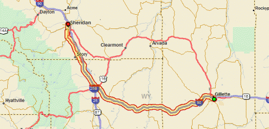
Tour Day 14: Gillette, WY to Sheridan, WY

August 31st, 2007

110.46 mi / 7:56:24 time / 13.9 mph avg. / 33.0 mph max. / 3587 ft. climbing
Staying at Alamo Motel, Sheridan

Last night’s motel was the most expensive so far (over $100, I think!), so at least it was good that they had the most extensive breakfast too. Waffles, hard-boiled eggs, English muffins, plus all the other usual stuff, and I sampled it all!

Near the Powder River, WyomingI got a pretty early start, and hopped right back on I-90 headed west. This time it’s truly the only option between Gillette and Buffalo; the occasional exits are sometimes simply right turns off the Interstate onto gravel roads. Once I cleared out of town, the traffic lightened up, and it was really nice riding.

I was making really good time, until about 65 miles into the ride, I noticed my bike suddenly felt like it had a rear suspension, which means the back tire was going down. This time it was an actual puncture, by a sharp piece of stiff wire. I noticed a couple of others stuck in the tire that hadn’t caused punctures, and pulled them out. Even with that delay, I still covered the 70 miles to Buffalo by around 1pm.

Riding on I-90
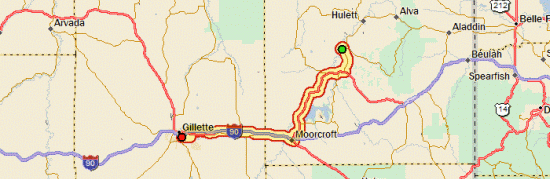
I first spotted the Bighorn Mountain range just a few miles into the ride, when they were still probably 80 miles away. That means they’re some real mountains. So for most of the day they were looming out there, constantly taunting me with their “you want a piece of me? you want some of this? well then come and get it!” That is, until I finally got close enough for them to see the slight glimmer of insanity in my eyes, at which point their bravado evaporated, and they attempted to flee to the west. Unfortunately for them, being mountains, they’re rather stuck in place. So I imagine they’ll be at the same spot tomorrow, waiting for me to begin my assault.

Bighorn Mountains Getting CloserHeading north to Sheridan wasn’t nearly as easy as the first part of the trip, mostly because there was a light but direct headwind. But then about 20 miles in, I noticed that the spring on my rear brake wasn’t latched right, so the brake had probably been rubbing the whole way from Buffalo. D’oh. Don’t know how much that actually slowed me down though. But the reason I noticed was because the rear tire was going down again! It was another piece of wire, and it seemed like a new one, but maybe it was just one I’d missed the first time? So that was a bit discouraging; I’m wondering if I just rode through one nasty pile of wire, or if my tires have suddenly become wire-attractors.

I’m again at a motel, for the usual reason: there just isn’t any good camping nearby. I’m back to the cheap ($45) independent though, and since my room has a microwave and a fridge (not to mention a bathroom that could be inside someone’s 1970s house) I bought groceries for an in-room dinner. This might be my last motel for a while though, as the camping should be pretty good from here on out.

Day 14

Tour Day 13: Hulett, WY to Gillette, WY

August 30th, 2007

63.10 mi / 4:53:05 time / 12.9 mph avg. / 30.5 mph max. / 2623 ft. climbing
Staying at Gillette Days Inn

Devils TowerLast night was probably only the second night that I haven’t put the rainfly on the tent. I almost wish I that I had used it, not because it was raining, or because it was cold, but because the moon was so darn bright. Bright enough to read by!

At Devils TowerI woke up just before dawn and ate breakfast while I headed out on a hike around Devils Tower. It was nice that there are two trails that make concentric circles around the tower, so I could do half a loop on the outer one, do the inner loop, and then finish up the other half of the outer loop, for about five miles total. The tower is amazing (especially in the sunrise); probably the most impressive thing I’ve seen so far on the trip. Visiting it added a lot of miles to my total, but it was easily worth it.

Climbers on Devils TowerWhile I only saw one other person on the trail, I saw four guys a few hundred feet up stuck to the side (and strangely, could clearly hear them talking and shouting “on belay! belay on!”) Apparently 5000 people a year are crazy enough to climb the thing. To me, rock climbing is something that makes me say “Wow, that seems really hard, why would anyone want to do that?” But then I suppose the rock climbers might say the exact same thing about me. Still, on a bike, when you get tired, you can just stop. When you’re wedged into a crack in a cliff waiting for your partners to catch up, you really have no option but to keep flexing your muscles. But I’m sure it’s pretty nice when you get to the top.

Devils TowerSo that makes three National Parks/Monuments that I’ve hit in the last three days. I’m amazed at how clean they all are, and also how “wild” they all seem (well, Mount Rushmore is pretty tamed). I also love all the “Now Entering/Leaving BlahBlah National Park/Forest” signs, with their rock foundations and brown/green color schemes. They’ve really got a good branding thing going! Hmm, don’t think I have any pictures…

The hike meant that I didn’t hit the road until a little before 10am. There were some good hills to climb on the way down to Moorcroft, along with some more road construction over the peaks. This time it was 7 miles of milled surface, not a lot of fun. Beyond that, the Wyoming roads/shoulders have been really nice so far.

Coal MiningThen after lunch in Moorcroft it was west on I-90 to Gillette. I was going to take a road that paralled I-90, but it was closed somewhere along the line, so I just stayed on the Interstate the whole time, which was pretty empty anyhow. I saw my first oil wells, plus a big coal mining operation, and some big coal-carrying trains. Beyond that, not a lot of excitement (but that’s probably because I’ve gotten used to seeing hill and mountain vistas all around).

Gillette is a veritable metropolis, with an Applebee’s (that served a beer as fancy as Fat Tire), Home Depot, and Quizno’s right across the street, among other things. As an added bonus to the WiFi and Continental Breakfast, I discovered that the motel has laundry machines, so I was able to clean some clothes, particularly the ones that I had been wearing for at least five days straight. That orange shirt you see me wearing in all the pictures is a Mountain Hardwear Wicked Tee that I got for $9 from Dick’s, and it’s the best wicking t-shirt I’ve ever had. Light, comfortable, cool, and it only smelled half as bad as you would expect such a shirt to smell after a week of wear, hundreds of miles, and gallons of sweat!

Once again, I could watch WGN here (the Cubs were on tonight, I think I’m starting to really understand their nationwide fanbase). It really hit me how far I have come when they showed a between-innings shot of the moon rising against the black sky, while here, it was still sunny!

Day 13

Tour Day 12: Lead, SD to Hulett, WY

August 29th, 2007

85.91 mi / 5:46:52 time / 14.8 mph avg. / 42.0 mph max. / 2870 ft. climbing
Staying at Devils Tower National Monument Campground (3829 ft.)

Spearfish CanyonThe campground host was thinking we might get the first frost of the summer. We didn’t, but it was probably pretty close: my thermometer in the morning read 37 degrees! But inside the tent I’d apparently kept it warmed it up to the upper 50s, and I actually slept quite well. I wasn’t even wearing socks or my hat, so it’s nice to know that I have some margin left in there for when it gets really cold. I’m thinking I should get some diapers though, or maybe a catheter, because the inevitable need to urinate in the middle of the night sure is a pain when it’s that cold!

Spearfish CanyonUnlike yesterday morning that started with a giant uphill, today started with a giant downhill. Well, giant in length, not grade. In fact, it was almost the reverse of the long uphill grade yesterday. I always say that if you’re following a river or a railroad, you’ve found yourself a pretty good route. Yesterday I was on a railroad that was following a river most of the way, so it couldn’t get much better than that. Then this morning, I was following another river as it wound its way down Spearfish Canyon. For 20 miles I rolled down the 1-2% grade, which is perfect because you can mostly coast, but you aren’t wasting any energy with unnecessary speed (and the braking that comes with it). Oh yeah, and the canyon is awesome, with the cliffs rising up hundreds of feet on either side of the river/road. All through the last couple days I’ve been passing really nice summer homes and thinking “now that would be a nice place to live”. And Spearfish Canyon had some of the nicest places, including one that had a big sign at the entrance that read “A Little Piece of Heaven”. Perhaps a bit presumptuous, but it was true.

Looking Back On The Black HillsThen I hit the town of Spearfish, which sits at the northwest corner of the Hills. Spent a while in the library, and then since it had gotten 40 degrees warmer, I used their bathroom to change out of my winter clothes (I sure needed the Windstopper gloves and pants for that descent!) The line at Subway was too long, so I just got lunch at Safeway, along with a boatload of groceries. I’m into the part of the trip where I’m really craving bread-like things, so I got a big bag of bagels.

Entering WyomingFrom Spearfish, it was another 10 mostly-downhill miles north, then a left turn where I boarded the East Wind Express. That blew me uphill in no time, and then I reached Wyoming! Woo! The region is sort of a mix of the Black Hills and what I saw in South Dakota: basically the SD rolling grasslands, but this time with trees, and more rocky bits. And actually there were still the Bearlodge Mountains (I guess still a segment of The Black Hills) that I had to get over. It wasn’t very nice that they were doing road construction near the top of a 7% grade (you feel like kind of a jerk holding up traffic waiting to come the other way when you’re moving at 6mph), but coming down the other side was the best downhill so far: 30-40mph for a couple miles.

Devils TowerThen after cresting another rise, I could suddenly see the black shadow of Devils Tower rising out of the plains like a fist, even though I was still 17 miles away from it. I got into the campground a bit too late to explore, so I figure I’ll do that tomorrow morning. Still, sitting here at my picnic table writing this, I can look up and see it between the trees, and there is certainly something otherworldly (and almost frightening!) about it.

Day 12

Tour Day 11: Keystone, SD to Lead, SD

August 28th, 2007

54.01 mi / 5:15:53 time / 10.2 mph avg. / 31.5 mph max. / 3949 ft. climbing
Staying at Hanna National Forest Campground (5600 ft.)

[Editor’s note: I uploaded a bunch of pictures in the gallery. If I was more of a blogging pro, I’d weave them into my journals, but as at stands, I just threw ’em all up there captionless. They’re chronological though, and hopefully you at least recognize Mount Rushmore!]

Today was a nice lazy day to play in the Hills. Ok, a lazy day with 4000 ft. of climbing, but hey, it’s all relative, right?

In the morning the campground host was nice enough to let me charge up my laptop at his outlet. We were the only two people in the campground, and he was actually a pretty cool guy as far as lonely-guys-looking-for-someone-to-talk-with go. He does a lot of day trading, so he knows a good bit about tech companies, and said he’d head over the the Holiday Inn in Keystone every morning to steal their WiFi and make his trades.

Mount RushmoreThe lazy day got out to a nice start with a couple miles of “lazy” climbing (up to 11%) to Mount Rushmore. The woman at the gate waved me on through; I don’t know if that’s standard policy, but it saved me $8. Unlike the Badlands, they didn’t list a specific fee for bicycles, only cars and RVs. Maybe they figure not enough people will ever make it up the hill. I got there pretty early, and it was misty/foggy/cloudy, so I thought I might not be able to see the presidents at all. Luckily by the time I reached the viewing area, the fog had cleared nicely. At first it wasn’t as big as I was expecting, but I think that’s just because the main viewing area is pretty far away. When I did the loop trail they got a lot bigger.

Off-Roading on Centennial TrailFrom there I took an off-road shortcut along the Centennial hiking trail for half a mile, which brought me to a valley road and took me straight into Hill City. I stopped at a bike shop there to buy a tube, and found out that the woman working there grew up in Hoffman Estates! Then it was on to the library (located inside the high school) which was the first one I’ve stopped at without WiFi, but they had a wired connection I could use so that was just as good. Then lunch, and all of a sudden it’s 2pm and I’ve only gone 13 miles.

On The Mickelson TrailFrom there I got on the Mickelson Trail, a 106-mile rail-trail (for the railroad geeks, it was built by the Chicago, Burlington, and Quincy Railroad). With all due respect to the grand old Elroy-Sparta trail, I think there is a new king. The tunnels were a lot less impressive, but the views were spectacular, and with its steady grades and gravel surface, it makes for a very relaxing path through the hills. Outside of Hill City, I saw one cyclist (putting his bike in his car), a group of three walkers, and that was about it. Even the rest stops were excellent, with shelters that you could take cover in under bad weather. It eventually took me up to a peak of over 6000 ft., after an incredibly steady 18-mile climb, at which point I got off and switched to the road.

Hanna National Forest CampgroundIt was getting fairly late by this time, and on a day that never broke 68 degrees (even though it had cleared up early on and stayed sunny), it was down to the low 50s as I was making my high speed descent to the campground. I cooked dinner to warm myself up a bit, and then holed myself up in the tent, hoping that I wouldn’t wake up inside an icicle. When I was registering with the campground host, he said “Well, you know, this is called ‘Icebox Canyon’!” (and it is, it says so on my topo map!)

Day 11

Tour Day 10: Interior, SD to Keystone, SD

August 27th, 2007

99.46 mi / 8:56:07 time / 11.1 mph avg. / 36.5 mph max. / 4221 ft. climbing
Staying at Grizzly Creek National Forest Campground

Neil’s Tour Day 10: An Epic Struggle in Two Acts

ACT I
: 75 miles of riding WNW from Badlands National Park to Rapid City

Badlands At Dawn
Scene 1
[Setting – Neil is seen amidst the Badlands shortly after sunrise, riding into a stiff headwind]

Neil: “Man, can you believe this wind? This is ridiculous!”
Prairie Dogs: “Squeak! Squeak!”
End Scene

Scenic, South Dakota
Scene 2
[Setting – Decrepit gas station/store in Scenic, SD (reported population: 37, apparent population: 1) Foreign woman enters to speak to the last surviving member of the town, who is of a similar age as the town and falling apart just as badly]

Foreign Woman: “Fouala?”
Old Man: “Food?”
Foreign Woman: “Fowual?”
Old Man: “WHAT?”
Foreign Woman: “Fuwol?”
Old Man: “Fuel! Pump 3.”
Foreign Woman: “???”
Old Man: “THREE!” [Foreign Woman exits]
Neil: “This will be all”
Old Man: [slowly inspects food items with a magnifying glass, including Little Debbie Cherry Pie, Little Debbie Star Crunch, and Orange Powerade. Pushes buttons on cash register and points to total: $3.22]
End Scene

The Black Hills
Scene 3
[Setting – Neil is seen crouched over the handlebars riding through the empty hills of South Dakota. The wind is even stronger than before; occasionally an old woman clinging to an umbrella will be seen flying through the air]

Neil: “Man, can you believe this wind? This is ridiculous!”
Longhorn Steer [staring at Neil]: “………….”
End Scene

INTERMISSION (serve McDonald’s Double Cheeseburgers in the lobby)


ACT II
: 20 miles SSW and 1800 ft. up from Rapid City towards Mount Rushmore

Advertisement(?) For Presidents Park
Scene 1
[Setting – Neil is seen climbing a 6% hill out of Rapid City, moving along at a brisk 6.5mph]

Neil: “Man, can you believe this hill? This is ridiculous!”
Pine Trees: “……….don’t we smell nice?”
End Scene

US 16A Near Keystone
Scene 2
[Setting – Neil is seen flying down a 5% hill towards Keystone]

Neil: “Can you believe that the northwest wind that was such a pain during Act I didn’t change direction, so it’s now a big help during Act II?”
Neil: “Yeah, that was pretty cool, and it made these 20 miles seem like nothing compared to the first 75”.
Neil: “Hmm, do you think you should really be talking to yourself, and referencing you own play within the dialogue?”
Neil: “Why not? You weren’t particularly concerned about the trees talking to you in the last scene”.
End Scene

Grizzly Creek National Forest Campground
Scene 3
[Setting – A helicopter shot (hopefully we can get the budget for this!) flying within feet of Lincoln’s 10-foot tall bouffant on Mount Rushmore, then swooping down the mountain and over the forest until it gets low enough to see Neil sitting at a picnic table in a beautiful campground, surrounded by tall pine trees and rocky cliffs, and typing on his laptop computer]
Computer: “clickclickclickclickclick”
Some Animal: “sqauw!………….squaw!”
Grizzly creek: “gurgle gurgle gurgle gurgle”
End Scene

Day 10

Tour Day 9: Murdo, SD to Interior, SD

August 26th, 2007

76.49 mi / 5:58:20 time / 12.8 mph avg. / 32.0 mph max. / 2608 ft. climbing
Staying at Badlands National Park Campground

Photography While RidingIt seems like my previous tours have had a day, about a week or so in, that make me say “yeah, now that’s why I do these rides!” Well, I’m still waiting for that day on this tour. Haha, no, just kidding! Today was totally that day!

Not only was there no rain today, there was barely even a cloud. That meant that my thermometer eventually reached 105 (I’m presuming it exaggerates a bit while in the sun, but even in the shade it said 97). It never really felt too bad though, probably because of that “dry heat” thing, as well as a strong south breeze.

Badlands National ParkThe area west of Murdo was even more empty and “Dances With Wolves”-like than before; lots of rolling grassland with plenty of rolled up hay bales, but not a lot of cattle, and not a lot of buildings suggesting that the land belonged to someone. Since Old Highway 16 / Business 90 spent a lot of time quite close to I-90, I did see plenty of signs for Wall Drug and other various tourist nonsense. Last night in Murdo I spoke to an older local couple who was quite knowledgeable about the area, and when they found out I was getting away from the Interstate and going through the Badlands, they said “Oh…but then you’ll miss Wall Drug! It’s really quite something.” I was surprised they’d say such a ting, but then I figured that maybe it’s just what you’re used to. Living near one of the biggest cities in the country, I’m constantly inundated with crass commercialism; out here, there are usually no businesses in a town that are even part of a chain. So the opportunity to experience crass commercialism must be just as exciting to them as experiencing natural beauty is to me. I passed someplace called “1880 Town” that has a logo (and full-size model alongside the road that I saw) of a boy leading a dinosaur skeleton. I didn’t even bother to check if it was some kind of weirdo Christian fundamentalist thing. It is interesting to notice that a large percentage of vehicles traveling I-90 appear to be vacationers of some sort: either RVs, or cars and SUVs with bicycles strapped to the back.

Notch TrailI did some more ups and downs today, climbing 50ft, then dropping 30, and so on. When I crested one hill at something like 2700ft., I looked to my left, and wow, there are some badlands! I walked off into the grass to take a picture, and almost stepped on a cactus. This was still a long way from the National Park, but then as I got closer, I could see the jagged cliffs rising up above the landscape.

Badlands National ParkThe park is amazingly beautiful. Since it was a short day, and I crossed into Mountain Time at some undefined point (“gaining” an extra hour), I got into the park at around 2pm. Before going down to the campground, I took a hike up “Notch Trail”, which is labelled “strenuous”. Of course, that means it was almost empty. And it was quite strenuous, and dangerous, with a rope-and-log ladder you had to climb and plenty of cliffs you could fall off. That’s my kind of trail, with a great view at the end (and really, you can roam free and go hiking/climbing anywhere in the park). Then I rode over to the campground, realizing that it was perhaps the first time I’d rode at ~10mph without minding at all, because there was just so much for me to gawk at. I grabbed a campsite, worked on my bike a bit (there aren’t many trees, but each campsite has a wooden awning over the picnic table, which is really nice), and then got some dinner at the park restaurant while I waited for the sun to get lower.

Badlands National ParkThen it was over to “Saddle Trail”, another steep, treacherous climb, and plenty more incredible views, with the setting sun lighting up the cliffs. I climbed up to the very peak of a mountain and sat there all monk-like to watch the sun disappear. Then I turned around, and there was the almost-full moon rising. Perfect. I managed to get back down from the mountain without killing myself, and now the moon is even lighting up camp. Now I think I’ll go to sleep while listening to Calexico’s “Feast of Wire”.

Day 09

Tour Day 8: Kimball, SD to Murdo, SD

August 25th, 2007

94.89 mi / 6:30:58 time / 14.0 mph avg. / 25.0 mph max. / 2713 ft. climbing
Staying at AmericInn Motel

Missouri River ValleyTwo bowls of Raisin Bran, a donut, an English muffin, and four mini-muffins got me started out right. It was back on Old Highway 16, where the first vehicle I saw, six miles in, was another bicycle. At about 20 miles, I dove down into the Missouri River valley (the sign said 6% grade, but it was never more than 4%, liars). The hills tumbling down the valley were a new sight, and along with crossing the river, they signaled my entry into “The West”. I got a 570 calorie “Cream Cheese” (?) muffin at the bottom; sorry I haven’t kept up with the Little Debbies, they seem a little less common out here. Strangely, the gas station I stopped at had a rack dedicated to Goose Island beer. Too bad it was 10:30am. That reminds me, last night when I asked the waitress what beer they had, she replied “Just about anything that comes in a can or bottle!” I don’t think I was completely successful at hiding the look of scorn that flashed across my face. Sorry! (I got an MGD in a bottle, by the way!)

After crossing the river, I did my first Interstate riding for nine miles, including a 300ft. climb out of the valley. It wasn’t too bad, but man, those trucks are loud. I could still hear them most of the day, even though I was on a road that was usually a mile away from the Interstate, so that tells you how loud they are when you’re 10 feet from them.

South Dakota SkyOverall, it was a pretty nice day. Oh yeah, finally, the first day without any rain! The state doesn’t feel nearly as desolate as I thought it would, although it certainly helps that I’m right near the Interstate. It probably also helps that it’s 70-80 degrees and green. If I was getting blasted with 95 degree heat and surrounded by dusty grass, it would probably be a lot worse. That’s not to say it’s not pretty empty: I would literally see about four cars per hour (which means that it’s no problem at all to stop on the side of the road and relieve myself!) There are so few people living here that they haven’t even gotten around to paving most of the roads yet! (usually on the main street in a town will be paved, if that). But there is plenty around to keep my interest. I gained over 1000 ft. of elevation from the river, and there are definitely lots of hills starting to rise up around me. I passed fields of sunflowers, lots of ranches, and beehives, which didn’t seem to be suffering from the mysterious bee death.

SunflowersI was going to hit Super 8 #3 in Murdo, but the AmericInn lured me in with their cheap rate ($44 total). I would have no problem camping tonight, but I really don’t see the point of camping in what is essentially a parking lot in the middle of a town. I’ll wait ’til I get to some more natural areas. I got dinner at a diner, and finished it off with a Banana Split, which was both my second ice cream product of the day as well as the trip (it finally got warm and dry enough!) I really had to put in an effort to eat even more than usual to reload the calories after yesterday’s ride.

Tomorrow I roll 70 easy miles to the Badlands. That means I’ll be out of touch for at least a day, maybe more, so don’t worry, I’m probably not dead, I’m just not near the Internet. I want to say thanks to everyone for all the emails and comments, I really love reading them. And I mean to reply, but I just haven’t come across the time yet!

Day 08

Tour Day 7: Brandon, SD to Kimball, SD

August 24th, 2007

126.24 mi / 8:26:32 time / 14.9 mph avg. / 26.0 mph max. / 2219 ft. climbing
Staying at Kimball Super 8 Motel

Hot Water TowerSince yesterday was a short day, the plan for today was to get on the road as early as possible and see how far I could make it. Thing is, the early stop yesterday left me with a dilemma: I want to camp at Badlands National Park, and I was 280 miles away from it. That would be four 70 mile days (shorter than the required average) across fairly unexciting and easy roads while wasting tailwinds. Or, I could try to make it there in three. Of course, I decided to shoot for the latter. It ended up being the longest day I’ve ever done on my bicycle, and probably the longest ride I’ll ever do in my life.

Roadside CornIt started over some big gravel hills leaving the park (I had to cross the Big Sioux River twice!) As I left Sioux City behind me, I ran into a backpacker/hitchhiker waiting under the I-90 overpass and we chatted for a bit. Sixty miles later when I arrived in Mitchell, I turned a corner, and there he was again! Apparently he’d gotten in an hour earlier, and, like me, was looking for the library. I missed the Corn Palace, but for some reason there were kernels of corn littering the shoulder for miles approaching Mitchell, so I figure that was close enough.

Most of the riding today was pretty easy, on nearly deserted roads, with minimal grades and a slight tailwind. South Dakota changes from “Iowa” pretty quickly. The cornfields get replaced by pasture with herds of cattle, and it has much more of a “where the buffalo roam” feel (though the only buffalo I’ve seen so far were in a pen on the side of the road). At about mile 100, I rode through about 15 minutes of minor drizzle (not even a shoe-top wetter, much less a shoe-filler). The only reason I even mention it is because it prevents me from legally saying “Finally, a day without rain!”

This isn’t something I could have done on the first day of the trip, but now I’ve gotten broken in enough that I can do it without completely destroying my body. My calves are a little sore, but my hands and butt and feet (my normal problem areas, especially with all the wet) are just fine. Still, there was no way in hell I was going to sleep on the ground after 126 miles (especially since there aren’t any “natural area” campgrounds around here). Conveniently, there was a diner with all-you-can-eat buffet right across the street. They had high school football on the radio there (even playing in the bathroom!) so that gives you an idea what kind of country this is. And they have WGN on TV here, so I could watch the White Sox lose! I should have one more long-ish day tomorrow, and then after that, I can coast the rest of the way!

Day 07

Tour Day 6: Sibley, IA to Brandon, SD

August 23rd, 2007

54.02 mi / 3:39:44 time / 14.7 mph avg. / 22.0 mph max. / 1019 ft. climbing
Staying at Big Sioux State Recreation Area

Throughout all this rain, I’ve been rather surprised at how my spirits have stayed pretty high. Today, the cumulative load must have reached my breaking point, and I came down crashing hard for a while.

The evening was fine: cool, rain-free, and I got some good sleep. But then at 5am, the rain started again. Eventually I got up, pulled all my stuff out of the tent and over to the picnic shelter, and then dragged the tent over to take it down and try to dry it off a bit. All the drying and packing takes a bit more time, so I didn’t get rolling until around 9am.

The riding actually wasn’t bad, I had a nice tailwind, and even with the soaking rain, I did the first 25 miles without stopping. But when I stopped at Rock Rapids, the prospect of doing 60 more miles in the stuff was just too much, especially since I was then getting cold too. After drying out a bit under a picnic shelter, I went to the library to check out my options. By the way, that’s another bad thing about being wet all the time, it’s hard to go inside buildings without making a mess of them. I briefly considered just staying in a motel in town, but it looked like the rain might stop in the afternoon, so I got some Subway across the street. Another bad thing about being wet and cold in the summer is that most buildings are even colder inside than it is outside, even though it was only 68 degrees outside! So I left there as fast as I could and went back to the library for a final weather check and planning adjustments, and off it was in the mist again (it had lessened from the morning, so I was wet, but at least my shoes weren’t completely filled with water).

Entering South DakotaAs I neared South Dakota, the rain stopped, and less than a mile from the border, the sun came out! It was as if Iowa was saying “wait, don’t go, we’ll stop messing with you, promise!” You know what? Screw you, Iowa! I’m outta here. But seriously, despite all the rain, it was a nice state to ride through, and I can’t complain about the favorable winds. I did it in about four days total, so I don’t know why those RAGBRAI losers are taking seven.

CloudsI got a spot in the state park along the Big Sioux River, rode into Brandon for some food and supplies, and given my short day, even had time to do a little mud-filled hike along and over the river (on a bouncing suspension bridge!) The skies have cleared up, so let’s hope that the weather reports are true and that South Dakota treats me a little more nicely.

Day 06

Tour Day 5: Algona, IA to Sibley, IA

August 22nd, 2007

100.14 mi / 6:49:40 time / 14.7 mph avg. / 25.5 mph max. / 1224 ft. climbing
Staying at Sibley Town Park

When you’re in Iowa, the second question everyone asks you (after “Where you headed?”) is “Have you done RAGBRAI?” That’s a hugely popular organized ride that crosses Iowa in a week, with 10,000 riders per year. The route goes from west to east, and is different each year. It’s apparently quite the boon to small-town economies if they are lucky enough to be on the route (I’ve seen towns with dedicated websites for it). When I asked the lady operating the store in tiny Fenton if RAGBRAI had ever come through there, she was almost indignantly proud to say that it’s been through twice, and they’re famous for feeding the cyclists homemade pies (“we don’t got no pies today, though”). I think it probably helps me out a lot to have such a highly visible cycling event in the state; it makes everyone familiar with the concept of riding bicycles on the roads, so I don’t seem so strange to them.

Lonely RoadOk, then the ride. After more rain at night, the morning was actually dry, so packing up was fairly easy, and I could even see the sunrise again. But then shortly after, the fog rolled in, along with the clouds. Eventually it turned into a light drizzle, but was tolerable. I made it onto SR 9, which finally put me back onto my planned route. Lunch’n’library today was in Estherville. If only libraries served food, they’d be the ultimate location. Free WiFi, bathrooms, and comfy chairs to rest my weary butt. Though the librarian today didn’t seem to know what WiFi is. “What? Oh, that? Sometimes it works, sometimes it doesn’t, and with the weather today…” But it worked, just as it has in every library so far.

Right out of Estherville I did a 200 foot climb, so I spent half the day riding at around 1300 ft. and then half riding at around 1500 ft. You can actually see the notch on the detailed elevation profile. In the midst of that plateau is the “Great Lakes” region of Iowa, which really aren’t all that great if you’ve seen the real Great Lakes, but I guess they’re natural, which must be rare in the area. About a quarter of Iowa’s State Parks are located in the area, but it was too early for me to stop. Though the rain did stop at that point.

WindmillsI discovered that they farm more that corn in Iowa, they farm wind too. I’d noticed on Osceola County’s website they made a mention of their windmills, and it’s true, there were quite a lot of them. Yesterday I’d seen three Oversized Load trucks go by, each carrying what looked almost like an airplane wing. Today I finally put two and two together and realized they were blades for a windmill. I think it was the enormous size of them that threw me off. If you imagine each blade of the windmill being a really, really long semi truck spinning around, that gives you an idea of the scale. It’s funny, every once in a while somewhere I’ll see a yard sign that says “No Wind Farms!” I think “who could be against wind farms?” Maybe I’ve just been seduced by the clean-energy marketing, but when I see them, they’re almost beautiful, and a symbol of high technology. Maybe it’s just the ethanol growers who don’t want ’em.

I’m camped at a town park/swimming pool/golf course in Sibley. Just after I arrived, it started drizzling again, so I set up the tent under a picnic shelter to dry it out, and cooked dinner there too, and then transferred everything over once it stopped.

Day 05